
The Kootenay Rockies region of British Columbia comprises the Kootenays and the BC Rockies, and plenty of water and mountain ranges! The most westerly are the Monashees, followed by the rugged Selkirks, defined on their western flanks by the Arrow Lakes and Slocan Lake, and on the east by the spectacular Kootenay Lake. Farther east are the Purcell Mountains and the BC Rocky Mountains. Major cities are Castlegar, Nelson, Cranbrook, Kimberley, Invermere, Radium Hot Springs, Revelstoke and Golden.
The Kootenays
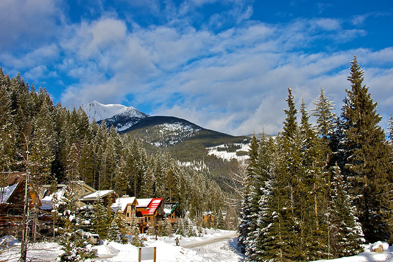
Dominated by mountains and water, the Kootenays region of British Columbia is cradled by the Monashee Mountains to the west, and the Selkirk and Purcell Mountains to the east. Between these ranges are the enormous Arrow and Kootenay Lakes, and the major wilderness parks of Valhalla and Kokanee Glacier.
BC Rockies
This region is a motherlode of serious adventure, with the mountainous parks presenting some truly extraordinary landscapes to explore. The Columbia Valley is surmounted by the Rocky Mountains on the east and the Bugaboos on the west, with the Columbia River rolling through the southern part of the valley.
The Kootenays
Two geographical features dominate the Kootenays: mountains and water. Four parallel mountain ranges, running in a generally northwest direction, march successively across the southeastern British Columbia landscape. The most westerly are the Monashees, followed by the rugged Selkirks, defined on their western flanks by the Arrow reservoir system and Slocan Lake, and on the east by the spectacular waters of Kootenay Lake. These two mountain ranges and accompanying lake systems define this district. Farther east are the Purcells, then the Rockies, outlining the area known as the East Kootenays.
The other major north-south water system in this district is formed by Kootenay Lake (at more than 65 miles/105 km long, it’s one of the province’s largest freshwater lakes) and Kootenay River, which joins with the Columbia near Castlegar. The Crowsnest Highway east of Grand Forks provides a good introduction to the often steep terrain of the West Kootenays. Only intrepid travellers need apply to drive what is the highest-elevation paved highway in Canada, the Skyway. But you’ll want some time – and cooperation from the weather. During winter storms, avoid this route, particularly the stretch between Salmo and Creston, for avalanches are a fact of life and road closures inevitable. Alberta licence plates begin to appear more regularly in parks here; the Kootenays are almost equidistant from the Prairies and the West Coast.
By their very nature, the Selkirk Mountains define this part of the Kootenays. Highway 6 links silvan Salmo with Highway 23 and stern-wheeling Nakusp, and forms alliances with branches of Highway 3 (Crowsnest Highway) to wrap all who journey here in a seductive embrace. Love at first sight is the reaction of many visitors to the Kootenays.
Two of British Columbia’s major mountain wilderness parks, Valhalla and Kokanee Glacier, are situated here. Cody Caves, a unique area of karst topography, also occurs here. (A karst is a limestone region with underground drainage and many cavities and passages caused by the dissolution of the rock.) Serrated, glacier-cloaked granite peaks dominate the landscape. Huge lake-filled glacial valleys provide habitat for many kinds of wildlife and offer excellent opportunities for water-based recreation. The range of wilderness experiences offered throughout the West Kootenays is exhilarating and diverse. Hot springs, alpine meadows, spectacular winter recreation, wildlife observation, and photography are among the many reasons to visit.
Throughout both the East and West Kootenay regions winds the majestic Columbia River, with its source in Columbia Lake near the town of Fairmont Hot Springs on the Rockies’ western slopes. The river flows north for over 186 miles (300 km) before hooking west and south to begin its long journey – more than 250 miles (400 km) – to the US border. For nearly half this length it widens to form the Upper and Lower Arrow Lakes, vast reservoirs of water that moderate winter temperatures and help retain moisture in the local atmosphere, thus greatly influencing the types of vegetation found there. The river crosses the border just south of Trail and passes through Washington to its mouth at Astoria, Oregon.
The Kootenays wouldn’t be complete without at least a backroad or two for those travellers with a little time on their hands and an inclination to search out wilderness backpacking destinations and fishing holes. This route leads through the Lardeau and Duncan Valleys, which are hemmed in by the Selkirk Mountains. Steep-sided valleys force the peaks’ runoff into long, narrow lakes, from which fast-flowing rivers cascade south into Kootenay Lake. Dense stands of timber are constant reminders that here in the Kootenays, there’s still plenty of untouched wilderness to explore.
About 100 years ago, prospectors came to the West Kootenays, attracted by its rich ore deposits. Mining ghost towns can be found now, silent relics of past treasures. Some backroad travel to these ghost towns will enhance your visit to this extremely beautiful region. Visitors can learn about the development and history of the area at mining museums in Kaslo and New Denver.
The name Kootenay, used for the southeastern portion of the province, comes from the Kootenay First Nation, a group of linguistically distinct Native people. They occupy the East Kootenays, with their territory extending into northern Washington, Idaho, and Montana. The western portion of the district was also occupied by Interior Salishan Natives, linguistically and culturally related to the coastal people, or by Thompson River-Shuswap Natives, heavily influenced by the Athapaskan culture.
The British Columbia Rockies
For outdoor enthusiasts, the route from Creston to Crowsnest Pass is a motherlode of serious adventure. The British Columbia-Alberta border parks – Height of the Rockies Provincial Park, Elk Lakes Provincial Park, and Akamina-Kishinena Recreation Area – present some truly extraordinary landscapes to explore.
The Rocky Mountain Trench (also known as the Columbia Valley) is surmounted by the Rocky Mountains on the east and the Bugaboos on the west. Both are impressively high and rugged ranges. Equally impressive is the Columbia River, which rolls through the southern part of the valley. The broad waterway is an important stopover on the semiannual migration route for wildlife and a joy to travel in any season.
Highway 93/95 links Cranbrook at the south end of the Columbia River Valley with Golden, about 140 miles (230 km) north. A steady stream of travellers pass through the region, but few are fortunate enough to make a home in this blessed setting. The land will sustain agriculture only at its south end, leaving vast tracts of wilderness for the enjoyment of those who love the outdoors. For additional adventure, explore the northeast section of Highway 93, which runs from Radium Hot Springs into Kootenay National Park.

